Event Overview
On Friday at midday prayers, a magnitude 7.7 earthquake shook central Myanmar along the Sagaing Fault near Mandalay, the nation’s second‑largest city. The tremor reached its peak strength over a shallow fault line stretching roughly 400 kilometers and caused surface shift of up to six meters in spots close to the epicenter.
People felt strong shaking as far away as Bangkok, where buildings swayed from long‑period ground motions. City streets cracked and homes tilted within minutes of the initial shock, and rescue crews raced across villages to search for survivors and restore power lines.
Remarkable Real‑Time Video
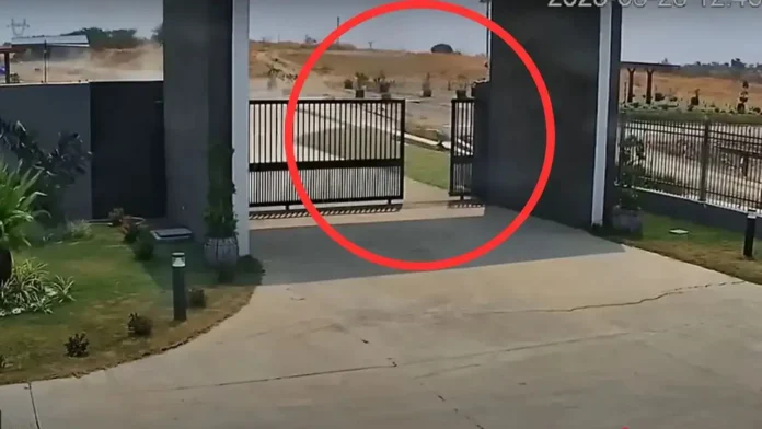
A nearby CCTV camera captured the rare sight of earth splitting as the fault moved, showing a two‑and‑a‑half‑meter gap opening in just 1.3 seconds. Researchers at Kyoto University applied advanced pixel‑tracking tools to this video and confirmed that the fault trace curved in a pattern that models had long forecast but never directly seen.
More than a simple record of damage, this footage served as a clear view of a pulse‑like rupture that moves as a brief, focused burst instead of a slow, steady shift. In addition, camera calibration allowed scientists to convert pixels into real distances, making it possible to measure the speed and shape of the fault slip with precision.
Video Analysis Methods

First, scientists stabilized the raw video and corrected lens distortion so each frame could align perfectly. Then they marked fixed reference points on the ground and applied two tracking systems: a classic grayscale template matcher and a modern vision transformer tracker. Both tools ran side by side and gave matching results that teams cross‑checked with manual frame‑by‑frame measurements.
They noted that the rupture front raced near six kilometers per second at the start and later slowed to around three kilometers per second as it passed the camera site, 124 kilometers south of the quake origin. The combined data produced a slip‑rate curve with a peak velocity of nearly three meters per second right at the rupture front.
Pulse Rupture Insights
This brief, intense burst of motion confirms the pulse‑type rupture theory that seismologists have held since they saw distant seismic records suggesting short‑lived energy releases. The real‑time CCTV clip acts like a high‑speed camera on the ground, revealing the fault’s curved path and showing that stress release can dip briefly before racing again.
In fact, satellite scans had detected a drop in slip of about two to three meters near the same region, hinting at a local stress trough that interrupted the fast rupture before it re‑accelerated.
Scientific Impact and Future Research
Now that researchers hold direct visual proof of pulse‑like ruptures, they can refine dynamic models that forecast how quakes unfold beneath our feet. Teams plan to feed the time‑series data into physics‑based simulations and test different friction laws under field conditions. Earthquake hazard maps should improve as scientists learn which fault sections might jump to supershear speeds. Communities in quake zones will benefit from clearer ground‑shaking estimates, and emergency planners can sharpen response plans in areas at risk of fast‑moving ruptures.
Sources: sciencedaily.com

