
Satellite and Drone Footage Expose Boundary Shift in Gaza
Newly analysed satellite and video evidence suggests that Israeli forces are exerting control deeper into Gaza than what was outlined in the latest ceasefire deal with Hamas, according to a BBC Verify investigation.
The findings reveal that the Israeli Defence Forces (IDF) have placed “Yellow Line” boundary markers several hundred metres inside the Gaza Strip, exceeding the withdrawal limits publicly presented by Israel earlier this month.
Under the first phase of the ceasefire agreement, Israel was expected to retreat to a line marking Gaza’s northern, eastern, and southern edges — symbolised by yellow blocks. However, new footage shows these markers significantly further inside Gaza, indicating that the actual control line extends beyond the boundaries agreed upon in the deal.
Boundaries Extend Hundreds of Metres Inside Gaza Strip
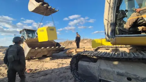
The IDF’s drone footage and geolocated videos confirm that in northern Gaza, near the al-Atatra neighbourhood, six yellow concrete blocks were placed up to 520 metres beyond the expected ceasefire boundary shown on IDF maps.
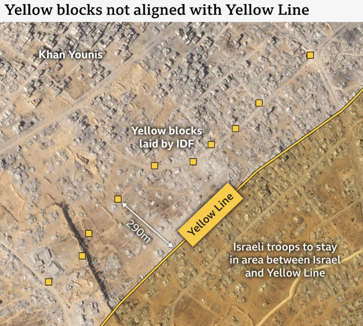
Similarly, satellite imagery captured on 19 October shows ten yellow markers positioned between 180 and 290 metres deeper into southern Gaza, near Khan Younis.
If these discrepancies are consistent along the entire border, Israel may be controlling a much larger area of Gaza than initially indicated in the ceasefire announcement.
The Israeli Defence Minister Israel Katz, who ordered the placement of the markers, warned that anyone attempting to cross the line “will be met with fire.” His statement followed at least two fatal incidents near the new boundary, where civilians reportedly came under Israeli fire.
IDF Defends Action, Calls It ‘Tactical Clarity’
When questioned by BBC Verify, the Israeli military did not directly address the boundary concerns. Instead, an IDF spokesperson said:
“Troops under the Southern Command have begun marking the Yellow Line in the Gaza Strip to establish tactical clarity on the ground.”
The Israeli government has released multiple versions of the boundary maps, leading to confusion over the official ceasefire line. Maps published by the White House, former US President Donald Trump, and the Israeli military before the ceasefire took effect on 10 October all showed differing interpretations of the division.
On 14 October, the IDF released its most recent map online, defining where Gaza residents could move safely. However, visual evidence now suggests that ground placements diverge from these maps, raising questions about Israel’s adherence to the ceasefire parameters.
Analysts Say Blocks May Create a Buffer or “Kill Zone”
Experts speaking to BBC Verify suggested that the placement of the yellow blocks may be deliberate, forming a “buffer zone” between IDF personnel and Gaza civilians.
According to Dr Andreas Krieg, an associate professor at King’s College London, this move aligns with Israel’s long-term security strategy aimed at insulating itself from territories it does not fully control.
“This gives the IDF space to manoeuvre and create a ‘kill zone’ against potential threats,” Dr Krieg explained. “It’s similar to a no-man’s land that effectively extends Israel’s defensive perimeter.”
Another analyst, Noam Ostfeld from Sibylline risk consultancy, noted that some blocks appear placed near major roads or visible walls, suggesting they are designed as clear warning markers for civilians.
Confusion and Danger for Gaza Civilians
Residents living near the temporary boundary report uncertainty and fear.
Abdel Qader Ayman Bakr, a resident of Gaza City’s Shejaiya district, told the BBC that despite Israel’s promises of clear demarcation, no visible markings exist near his area.
“Every day we see Israeli vehicles and soldiers nearby, but we have no idea if we are in a safe zone or a danger zone,” he said. “We live in constant fear because our homes are here.”
Reports indicate that the IDF has opened fire on individuals crossing the new line multiple times since the ceasefire began.
One incident on 17 October, east of Gaza City’s Zeitoun neighbourhood, reportedly killed 11 civilians, including women and children. BBC Verify geolocated footage of the aftermath about 125 metres beyond the IDF’s mapped boundary.
The IDF claimed it had fired at a “suspicious vehicle” that failed to stop after warning shots. The army said the strike was carried out “to remove the threat.”
Legal Experts Question Legitimacy of Expanded Zone
International law experts have questioned whether the expanded control zone breaches the laws of armed conflict.
Dr Lawrence Hill-Cawthorne, a professor of international law at the University of Bristol, noted that Israel’s obligations do not end even if individuals cross the line.
“Israel may only target enemy combatants or those directly participating in hostilities, and even then, civilian harm must not be excessive,” he said.
An Israeli military spokesperson responded that troops would continue operations to eliminate threats and defend Israeli civilians, adding that the concrete markers are being placed every 200 metres.
Rising Tensions and Ongoing Conflict
Israel launched its ongoing Gaza military campaign following the October 7, 2023 Hamas-led assault, which killed about 1,200 people in Israel and saw 251 hostages taken.
According to the Hamas-run health ministry, over 68,000 Palestinians have been killed in Israeli attacks since then.
The latest evidence that Israel’s “Yellow Line” may extend deeper into Gaza could complicate future ceasefire negotiations and fuel international criticism over the humanitarian impact of the war.